Get accurate topographic surveys in the UK
For your development project, receive accurate topographic surveys from our experts mapping the site, its features and topography.
Topographic surveysAs professional commercial measurement surveyors, we undertake detailed topographical survey work for architects, designers, building contractors and property professionals.


We are regularly asked; what elements are included in a topographical survey? In this article, we discuss the essential elements of a CADS topographical survey and how we deliver accuracy, clarity, and efficiency for architectural and construction projects.
A topographical land survey is fundamental in understanding the existing conditions of a site. The physical features and characteristics of the land are mapped by professional surveyors.
This essential accurate data assists AEC (Architecture, Engineering and Construction) professionals to make informed decisions during the design and construction phases, equipped with the necessary information to create successful designs.
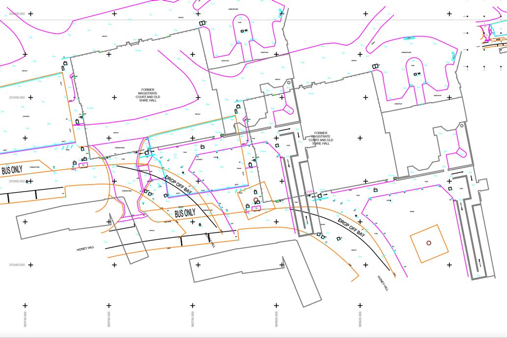 To maintain accuracy, all elements in a topographic survey are drawn to scale. The survey will include site levels on a maximum 5m/10m grid and soil mounds, with additional measurements taken at any significant changes in height. Understanding the site’s topography, helps identify areas requiring earthworks, drainage considerations, or foundation design adjustments. This also allows architects to visualise the contours of the land and construction professionals to understand the relationships various physical features informing planning and construction design.
For sites next to highways, a topographic survey records levels at key points. These include the back of footpaths, top and bottom of kerbs, and the crown of the road. This data shows how the site connects to nearby infrastructure. It helps with road design, access planning, and drainage assessments.
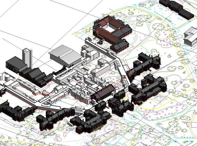
Plans of Buildings and Structures: Existing structures within the site boundary are shown on the plans including relevant details such as name, number, and description. Roof overhangs will be depicted using a broken line and, door positions with opening directions will be indicated. This creates awareness of spatial constraints and integration of the existing structures into the construction plans

Your topographic survey will also include internal levels. This is crucial data for architects, engineers, and construction teams when designing and coordinating construction activities within existing structures.
Understanding the heights of adjacent properties is vital to assess the impact of the new construction on the surrounding environment. This knowledge informs design coordination, compliance with local regulations and ensures the new design sits harmoniously withing the surrounding structures.
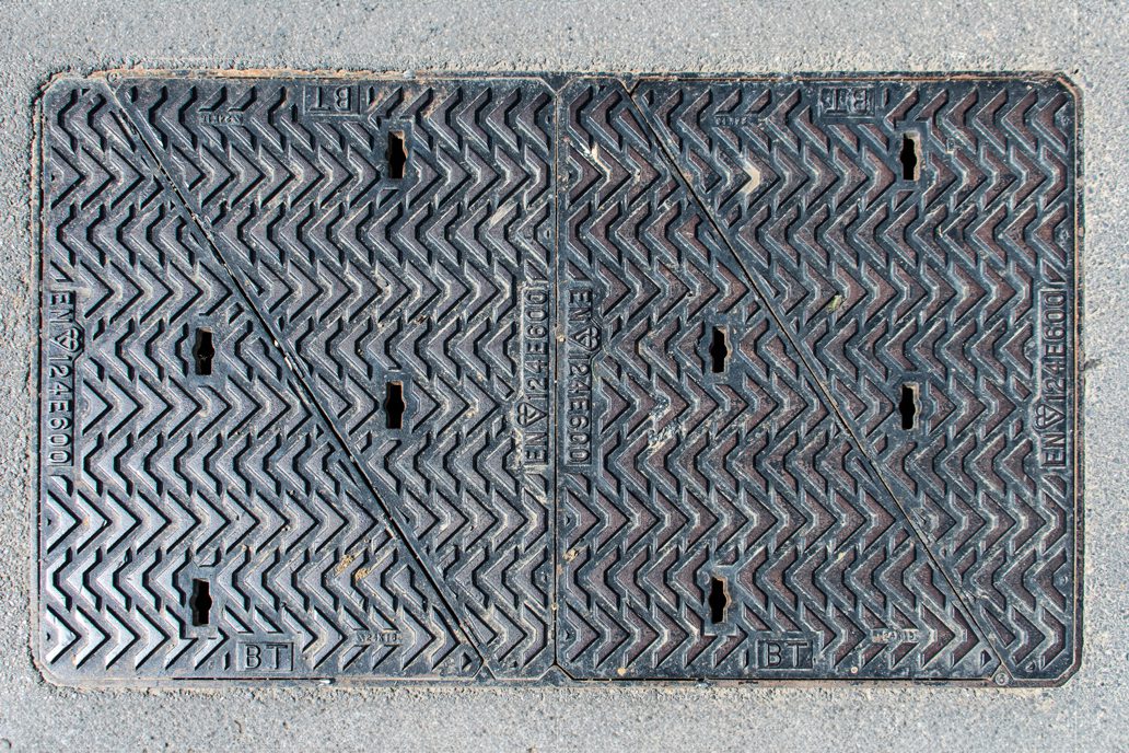 The topographic survey also identifies inspection covers, manholes, drains, gullies, earth rods, and stopcocks. Including these elements helps architects plan around existing infrastructure, enabling them to coordinate the development of designs with utility providers and avoid conflicts during construction.
To understand the site’s layout, the survey will include information about kerbs, walls, fences, railings, and gates and is essential for, drainage planning, and accessibility considerations. This information also assists construction and property managers to layout sites, plan considerations and identify legal boundaries.
Any visible excavation scars on the site are included in the topographic survey. These scars provide valuable information for construction and project managers regarding previous site activities, buried utilities, or potential hazards during construction.

If specified the topographic survey will map vegetation, including trees with a diameter above 100mm. This helps architects make informed decisions regarding the preservation or removal of vegetation, landscape design, tree preservation, and ecological/environmental impact assessments.
For drainage systems, the survey includes headwalls, indicating the pipe diameter and invert level. If there are definable edges of water on the site, the topographic survey will accurately represent these features. It will include water levels where relevant to ensure the accessible areas are noted. This information helps environmental consultants and property managers design drainage systems and conduct floodplain analysis. It also aids in preventing flooding or waterlogging issues and supports environmental impact assessments. Read more on the role of topographic surveying in Biodiversity Net Gain.

If required the survey can include site furniture such as bollards, telegraph poles, lampposts, signage, barriers, road markings such as give way signs, lane dividers, mini roundabouts, layout and marking of car parking spaces, including designated spaces for disabled individuals and parents/toddlers, and type of pedestrian crossings. This information facilitates civil engineers and urban planners with site planning, traffic management, safety considerations, parking design, accessibility planning, and traffic flow management.
Any changes in surface materials is mapped on the topographic survey. This could be as pavement or flooring transitions, the presence and details of steps, stairs, and ramps (including rise/going information and direction) The information assists designs for accessibility planning, coordination with architectural designs, and construction safety considerations.
The site survey drawing is oriented to the OS National Grid and Newlyn Datum, ensuring consistency in spatial reference and alignment with other mapping systems. This facilitates data integration and supports subsequent surveys and monitoring, promoting effective communication and collaboration among project stakeholders.

By including the essential elements discussed above in a topographic survey, construction professionals can effectively analyse and plan site development, understand existing conditions, and mitigate potential challenges. Architects can create accurate and well-informed designs, considering the existing context and meeting the needs of their clients and the surrounding environment.
Property managers use topographic surveys in their asset information models (AIM) and digital information management systems (DIMS) to plan landscapes and drainage systems, for construction and renovation projects to align with the as-built existing designs and for estate management to understand property boundaries. With accurate and detailed information at hand, project teams can optimise their designs, streamline architectural and construction processes, and deliver high-quality results.
CADS topographic survey team is qualified in BSc Geomatics and Surveying Engineering and BSc in Building Surveying. They hold CITB CSCS and DBS cards and is experienced in major multiple site survey programs (buildings and land) for national UK retailers, banks and building societies.
They have experience in conducting large scale topographic land surveying on sites across the UK with laser scanning equipment and Total Stations . This includes the extensive topographic survey of Queen Elizabeth Hospital, Kings Lynn and the Topographic and Utility measured surveys for historic Gresham’s School in Norfolk
To find out more about how we can help you, get in touch today.
For your development project, receive accurate topographic surveys from our experts mapping the site, its features and topography.
Topographic surveys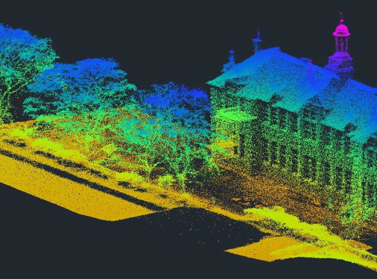
Map the natural physics and features across vast sites with a fast and cost-effective UAV drone survey from CADS.
Drone land surveys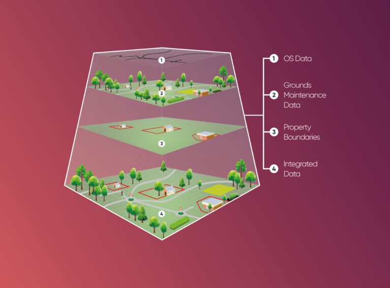
We provide cost and efficiency saving in asset management by helping clients create, maintain, update and analyse asset information within a Geographic Information System (GIS).
GIS and asset mapping